Hurricane Gonzalo 2014 UK: When will the storm hit Britain after Bermuda and how bad will it be?

A hurricane is heading our way. Or is it?
Hurricane Gonzalo is not as bad as it sounds – for us in Britain at least.
The hurricane is poised to hit the shores of Bermuda after the tropical storm formed earlier this week to the east of the Caribbean.
Currently a category four storm – the second highest there is – Gonzalo will batter the tiny island in the Atlantic, according to the Met Office, before heading our way.
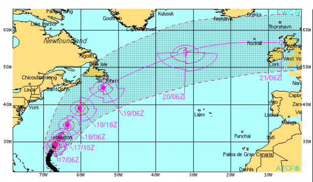
The journey over the Atlantic however, is expected to weaken Gonzalo and by the time it reaches UK shores on Tuesday 21 October and there is no chance of the country being hit by full blown hurricane winds.
Here’s what the current forecast of its trajectory looks like, from the Naval Research Laboratory.
It shows how the current wind of over 63 knots (72 miles per hour) will fall below 34 knots (39 miles per hour) by the time it nears the UK. So it might be windy, but it’s nowhere near the 140 miles per hour winds Bermuda is facing.

The remnants of the storm will sweep this way, but it will be nowhere near a hurricane and it could even dissipate completely while travelling across the pond.
In fact another tropical storm, this time called Fay, is actually expected to bring unseasonably warm weather to us this weekend.
Current Met office guidance says the UK should expect gales on Monday night and a short spell of heavy rain and there is some risk of flooding along the coast of the North Sea, though as with all weather, that’s changeable.
This is what Gonzalo looks like over Bermuda- that little orange dot just above the centre- right now.
